Categories in Khemkaran
Industries
Business Distribution by Industry in Khemkaran
| Industry Description | Number of Establishments |
|---|---|
| Shopping | 28 |
| Clothing stores | 12 |
| Grocery stores and supermarkets | 12 |
| Electronics stores | 11 |
| Restaurants | 9 |
| Religion | 9 |
| Education | 8 |
| Shopping other | 8 |
| Mobile phone stores | 5 |
Khemkaran Facts
| Local Time | |
| Timezone | India Standard Time |
| Lat & Lng | 31.14443, 74.55938 |
Map of Khemkaran
Interactive Map
Recent Nearby Earthquakes
Magnitude 3.0 and greater
| Date▼ | Time↕ | Magnitude↕ | Distance↕ | Depth↕ | Location↕ | Link |
|---|---|---|---|---|---|---|
| 9/23/18 | 5:45 AM | 3.7 | 37.7 km | 10,000 m | 21km E of Chunian, Pakistan | usgs.gov |
| 9/1/18 | 12:21 PM | 3.9 | 50.3 km | 10,000 m | 9km NNW of Kot Radha Kishan, Pakistan | usgs.gov |
| 7/17/16 | 11:53 AM | 4.5 | 24.9 km | 60,730 m | 8km ESE of Kahna, Pakistan | usgs.gov |
| 11/5/15 | 4:27 PM | 3.1 | 73.1 km | 59,820 m | 15km SSW of Narang, Pakistan | usgs.gov |
| 3/20/14 | 2:14 PM | 4.3 | 84.6 km | 46,030 m | 2km NW of Warburton, Pakistan | usgs.gov |
| 4/9/08 | 2:08 AM | 3.3 | 39 km | 49,400 m | India-Pakistan border region | usgs.gov |
| 2/15/05 | 9:48 PM | 4.2 | 88.3 km | 50,400 m | India-Pakistan border region | usgs.gov |
| 2/3/02 | 7:09 PM | 3.7 | 81.3 km | 33,000 m | Pakistan | usgs.gov |
| 1/27/02 | 10:22 PM | 4.2 | 11.8 km | 43,500 m | India-Pakistan border region | usgs.gov |
| 11/30/95 | 5:24 AM | 4.1 | 80.4 km | 78,700 m | India-Pakistan border region | usgs.gov |
Source: U.S. Geological Survey (USGS)
Khemkaran
Khem Karan (Punjabi: ਖੇਮਕਰਨ) is a town and a nagar panchayat in Tarn Taran district in the Indian state of Punjab. It was the site of a major tank battle in 1965 resulting it also being known as the graveyard of tanks. 1965 Indo-Pakistani War was wi..
Khemkaran Wikipedia Page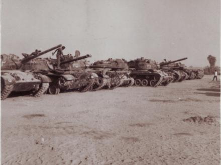


About Our Data
The data on this page is estimated using a number of publicly available tools and resources. It is provided without warranty, and could contain inaccuracies. Use at your own risk.