Industries
Business Distribution by Industry in Kisač
| Industry Description | Number of Establishments |
|---|---|
| Shopping | 15 |
| Cafes | 14 |
| All food and beverage | 12 |
| Car repair | 10 |
| Dentists | 7 |
| Religion | 6 |
| Pharmacies and drug stores | 6 |
| Corporate management | 5 |
| Other membership organizations | 5 |
| Post office | 5 |
| Wholesale of construction supplies | 5 |
Kisač Facts
| Local Time | |
| Timezone | Central European Summer Time |
| Lat & Lng | 45.35421, 19.72975 |
Map of Kisač
Interactive Map
Area Codes
Percentage Area Codes used by businesses in Kisač
Recent Nearby Earthquakes
Magnitude 3.0 and greater
| Date▼ | Time↕ | Magnitude↕ | Distance↕ | Depth↕ | Location↕ | Link |
|---|---|---|---|---|---|---|
| 12/23/18 | 6:33 AM | 4.1 | 95.1 km | 10,000 m | 2km NW of Hajducica, Serbia | usgs.gov |
| 2/7/08 | 4:45 PM | 3.6 | 95.7 km | 19,000 m | Serbia-Romania border region | usgs.gov |
| 9/20/07 | 10:46 PM | 3.3 | 79.8 km | 14,900 m | Serbia | usgs.gov |
| 7/30/07 | 8:51 PM | 3.1 | 63.8 km | 10,000 m | Serbia | usgs.gov |
| 3/15/01 | 7:01 PM | 3.6 | 94 km | 700 m | Serbia | usgs.gov |
| 2/1/99 | 8:38 AM | 3.3 | 98 km | 10,000 m | Croatia | usgs.gov |
| 7/21/94 | 5:13 AM | 4 | 94.2 km | 33,000 m | Serbia-Romania border region | usgs.gov |
| 10/13/93 | 11:21 PM | 3 | 86.4 km | 10,000 m | Croatia | usgs.gov |
| 1/14/93 | 8:23 AM | 4.1 | 98.1 km | 10,000 m | Serbia-Romania border region | usgs.gov |
| 12/19/92 | 9:34 AM | 4.6 | 98.2 km | 22,600 m | Serbia-Romania border region | usgs.gov |
Source: U.S. Geological Survey (USGS)
Kisač
Kisač (Serbian Cyrillic: Кисач, Slovak: Kysáč) is one of the suburban settlements of the City of Novi Sad in the South Bačka District of Serbia. It is situated in the Autonomous Province of Vojvodina. The settlement has a Slovak ethnic majority.
Kisač Wikipedia Page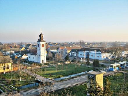

About Our Data
The data on this page is estimated using a number of publicly available tools and resources. It is provided without warranty, and could contain inaccuracies. Use at your own risk.